


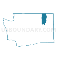
Orient Voting District, Ferry County, Washington
About
Outline

Summary
| Unique Area Identifier | 684174 |
| Name | Orient Voting District |
| County | Ferry County |
| State | Washington |
| Area (square miles) | 71.77 |
| Land Area (square miles) | 71.77 |
| Water Area (square miles) | 0.00 |
| % of Land Area | 100.00 |
| % of Water Area | 0.00 |
| Latitude of the Internal Point | 48.92819670 |
| Longtitude of the Internal Point | -118.29033630 |
Maps


Graphs
Select a template below for downloading or customizing gragh for Orient Voting District, Ferry County, Washington


Neighbors
Neighoring Voting District (by Name) Neighboring Voting District on the Map
- Barstow Voting District, Ferry County, WA
- First Thought Voting District, Stevens County, WA
- Lone Ranch Voting District, Ferry County, WA
- Rockcut Voting District, Stevens County, WA
Top 10 Neighboring County Subdivision (by Population) Neighboring County Subdivision on the Map
- Kettle Falls CCD, Stevens County, WA (7,292)
- Curlew CCD, Ferry County, WA (1,455)
- East Ferry CCD, Ferry County, WA (1,239)